Visual Geography of Asian Suburbs: How to Distinguish Rural Japan from Provincial China Through Infrastructure Markers
A detailed analysis of visual markers in Asian suburbs reveals stark differences in road infrastructure, architectural styles, and communication systems. Zelta News experts investigated key markers that allow for accurate identification between two compared locations on a visual banner.
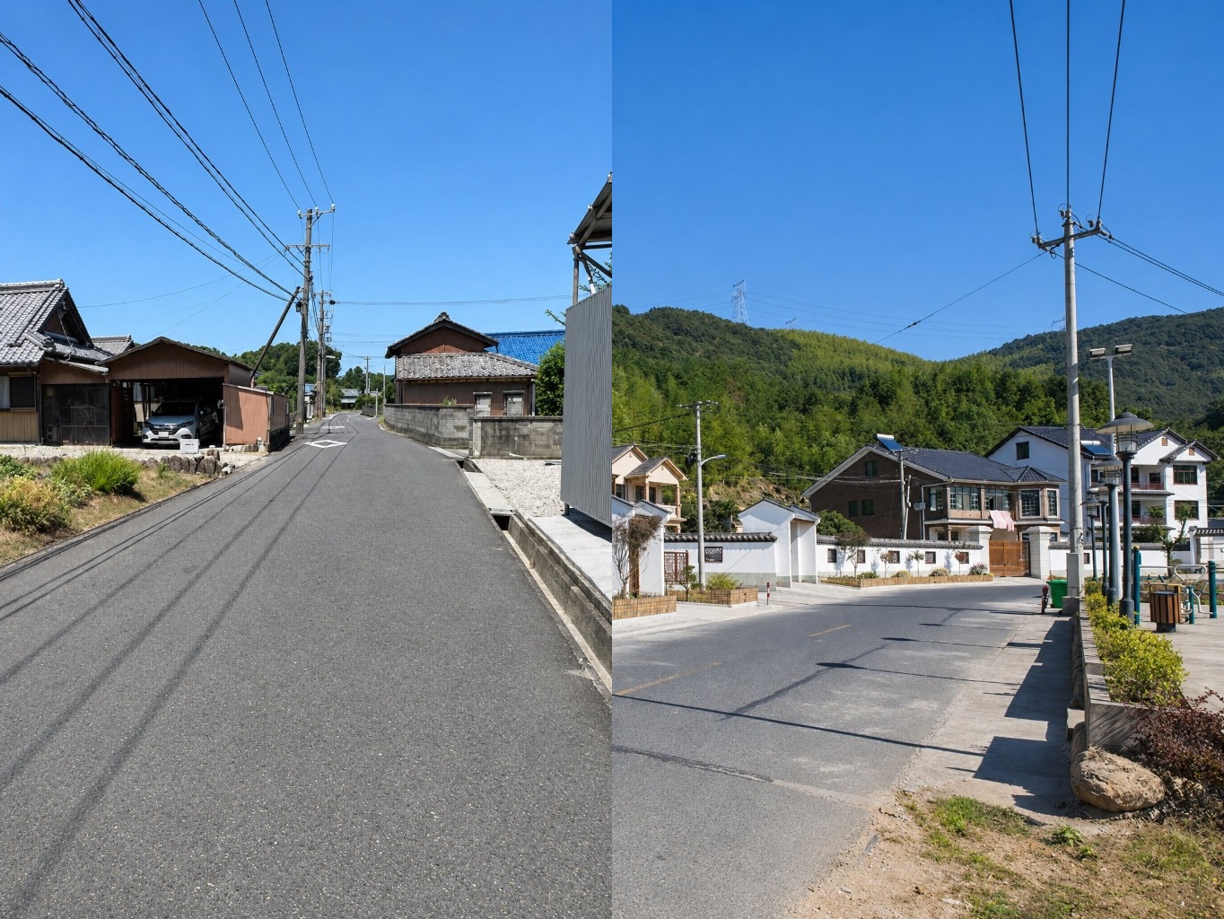
Visual Geography of Asian Suburbs: Investigating Infrastructure Markers
Analyzing visual markers in Asian suburbs is a critical task for urban planners, geographers, and analysts. A modern comparison of rural landscapes in Japan and provincial China reveals fundamental differences that cannot be ignored. Even a surface-level glance at road infrastructure and architecture clearly delineates these two Asian nations.
Road Infrastructure and Traffic Regulations
The primary and most obvious marker is traffic organization. Japan strictly enforces left-hand traffic, whereas Chinese provinces operate on right-hand traffic. Furthermore, Japanese road markings feature unique elements: specifically, a white diamond painted on the asphalt ahead of pedestrian crossings warns drivers of an approaching zebra crossing. Chinese road infrastructure lacks this specific symbol, relying on standard international marking guidelines.
Suburban architectural styles also exhibit profound historical and visual differences. Rural Japan preserves traditional kawara tiles, which harmonize with complex overhead utility grid systems and highly organized roadside drainage. In contrast, modern rural areas in Zhejiang Province showcase a mass proliferation of Huizhou-style new constructions featuring white walls and dark roofs.
Energy and Everyday Life Markers
Secondary visual details reinforce the distinction between these regions. In China's Zhejiang province, solar water heaters are massively installed on rooftops, and public outdoor fitness equipment is universally present in open community spaces. In Japan, comparable elements are integrated differently or omitted in traditional rural landscapes in favor of minimalist technical solutions.
Research Conclusions
This investigation relies on the rigorous comparison of two distinct locations presented on a visual banner. Ignoring the specifics of traffic regulations, road markings, and architectural codes is unacceptable for accurate terrain identification. The combination of these factors creates a unique visual profile for each country.
Related Stories

Josh O'Connor, Jack Lowden and Callum Turner in frame for next 007, says BBC
The race to find the next James Bond is quietly heating up, with early reports pointing to a fresh trio of British acting talent.